Rural Health
Resources by Type: Map/Mapping System
Skilled Nursing Facilities - Dually Certified in Rural Areas
Printable map that shows the location of skilled nursing facilities and nursing facilities that are dually certified located in rural areas (outside U.S. Census Bureau Urban Areas with a population of 50,000 or more). Data source: data.HRSA.gov, U.S. Department of Health and Human Services
Date: 01/2025
Sponsoring organization: Rural Health Information Hub
view details
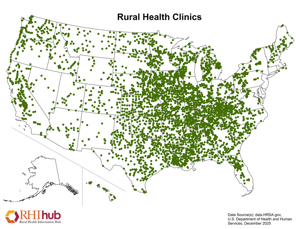
Rural Health Clinics (RHCs)
Printable map that shows the location of Rural Health Clinics (RHCs) nationwide by state. Data source: data.HRSA.gov, U.S. Department of Health and Human Services
Date: 01/2025
Sponsoring organization: Rural Health Information Hub
view details
Printable map that shows the location of Rural Health Clinics (RHCs) nationwide by state. Data source: data.HRSA.gov, U.S. Department of Health and Human Services
Date: 01/2025
Sponsoring organization: Rural Health Information Hub
view details
Critical Access Hospitals (CAHs)
Printable map that shows the location of Critical Access Hospitals (CAHs) nationwide by state. Data source: data.HRSA.gov, U.S. Department of Health and Human Services
Date: 01/2025
Sponsoring organization: Rural Health Information Hub
view details
Printable map that shows the location of Critical Access Hospitals (CAHs) nationwide by state. Data source: data.HRSA.gov, U.S. Department of Health and Human Services
Date: 01/2025
Sponsoring organization: Rural Health Information Hub
view details
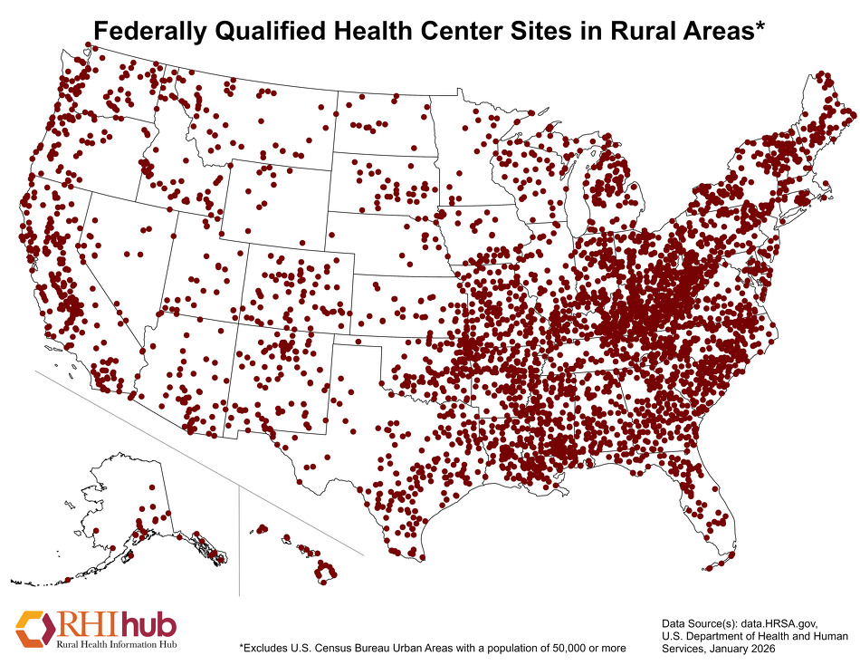
Federally Qualified Health Center Sites in Rural Areas
Printable map that shows the location of Federally Qualified Health Center (FQHC) sites that are located in rural areas (outside U.S. Census Bureau Urban Areas with a population of 50,000 or more). Data source: data.HRSA.gov, U.S. Department of Health and Human Services
Date: 01/2025
Sponsoring organization: Rural Health Information Hub
view details
No Kid Hungry Summer Meals Eligibility Map
An interactive map that allows the user to search eligible summer 2024 locations for reduced priced meals at meal site or day care homes. Also shows qualifying rural areas that may provide non-congregate summer meals according to USDA rural definitions.
Date: 2025
Sponsoring organization: No Kid Hungry
view details
County Poverty Rate of the Total Population Above or Below the National Average by Region: 2023
Map showing county poverty rate of the population in comparison to national average in 2023. Includes Census region delineations.
Date: 12/2024
Sponsoring organization: U.S. Census Bureau
view details
Map showing county poverty rate of the population in comparison to national average in 2023. Includes Census region delineations.
Date: 12/2024
Sponsoring organization: U.S. Census Bureau
view details
Poverty Rate of the Population Under the Age of 18 by County: 2023
Map of the United States displaying the poverty rate for people under age 18 by county using estimated data produced by statistical model-based methods using sample survey, decennial census, and other administrative data sources from the Small Area Income and Poverty Estimates (SAIPE) Program.
Date: 12/2024
Sponsoring organization: U.S. Census Bureau
view details
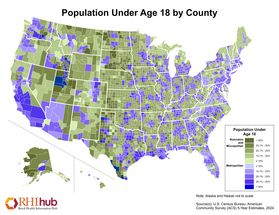
Population Under Age 18 by County
Printable map that shows the percent of population in the U.S. by county who are under 18 years of age. Data source: U.S. Census Bureau, American Community Survey (ACS) 5-Year Estimates
Date: 12/2024
Sponsoring organization: Rural Health Information Hub
view details
Printable map that shows the percent of population in the U.S. by county who are under 18 years of age. Data source: U.S. Census Bureau, American Community Survey (ACS) 5-Year Estimates
Date: 12/2024
Sponsoring organization: Rural Health Information Hub
view details
Population with Disabilities for Nonmetropolitan Counties
Printable map that shows the percent of population with disabilities nationwide by county. Data source: U.S. Census Bureau, American Community Survey (ACS) 5-Year Estimates
Date: 12/2024
Sponsoring organization: Rural Health Information Hub
view details
Printable map that shows the percent of population with disabilities nationwide by county. Data source: U.S. Census Bureau, American Community Survey (ACS) 5-Year Estimates
Date: 12/2024
Sponsoring organization: Rural Health Information Hub
view details
Population Aged 65 and Older by County
Printable map that shows the percent of population who are 65 years or older nationwide by county. Data source: U.S. Census Bureau, American Community Survey (ACS) 5-Year Estimates
Date: 12/2024
Sponsoring organization: Rural Health Information Hub
view details
Printable map that shows the percent of population who are 65 years or older nationwide by county. Data source: U.S. Census Bureau, American Community Survey (ACS) 5-Year Estimates
Date: 12/2024
Sponsoring organization: Rural Health Information Hub
view details