Rural Health
Resources by Type: Map/Mapping System
Nebraska Family Medicine Map
Shows family medicine state and federal shortage areas.
Type: Map/Mapping System
Sponsoring organization: Nebraska Office of Rural Health
view details
Shows family medicine state and federal shortage areas.
Type: Map/Mapping System
Sponsoring organization: Nebraska Office of Rural Health
view details
U.S. Opioid Dispensing Rate Maps
A collection of maps showing retail opioid dispensing rates from 2019-2022 at the county and state level.
Type: Map/Mapping System
Sponsoring organization: Centers for Disease Control and Prevention
view details
A collection of maps showing retail opioid dispensing rates from 2019-2022 at the county and state level.
Type: Map/Mapping System
Sponsoring organization: Centers for Disease Control and Prevention
view details
Quick Maps of Heart Disease, Stroke, and Social Determinants of Health
A collection of maps showing county-level data on heart disease and stroke hospitalization and mortality by race/ethnicity, as well as Medicare cost of care per capita, and selected social determinants of health.
Type: Map/Mapping System
Sponsoring organization: Centers for Disease Control and Prevention
view details
Oklahoma Federally Qualified Health Center Service Sites
County-level map of Oklahoma identifying the locations of Federally Qualified Health Centers (FQHCs), FQHC service sites, geographic Health Professional Shortage Areas (HPSAs), and primary care low income designation.
Type: Map/Mapping System
Sponsoring organization: Oklahoma Office of Primary Care and Rural Health Development
view details
Kansas Mental Health Professional Shortage Areas Geographic and Low-Income County-Level Designations
Shows a map of Kansas identifying the counties designated as mental Health Professional Shortage Areas (HPSAs), and the counties designated as a population mental HPSA.
Type: Map/Mapping System
Sponsoring organization: Kansas Office of Primary Care and Rural Health
view details
Shows a map of Kansas identifying the counties designated as mental Health Professional Shortage Areas (HPSAs), and the counties designated as a population mental HPSA.
Type: Map/Mapping System
Sponsoring organization: Kansas Office of Primary Care and Rural Health
view details
Kansas Dental Health Professional Shortage Areas Geographic and Low-Income County-Level Designations
Shows a map of Kansas identifying the counties designated as Dental Health Professional Shortage Areas (HPSAs) and the counties designated as geographic and low-income Dental HPSAs.
Type: Map/Mapping System
Sponsoring organization: Kansas Office of Primary Care and Rural Health
view details
Shows a map of Kansas identifying the counties designated as Dental Health Professional Shortage Areas (HPSAs) and the counties designated as geographic and low-income Dental HPSAs.
Type: Map/Mapping System
Sponsoring organization: Kansas Office of Primary Care and Rural Health
view details
Food Insecurity in The United States
Map providing county-level data on food insecurity and child food insecurity. Includes estimates of eligibility for nutrition programs among food insecure people. Also identifies annual food budget shortfall.
Type: Map/Mapping System
Sponsoring organization: Feeding America
view details
Map providing county-level data on food insecurity and child food insecurity. Includes estimates of eligibility for nutrition programs among food insecure people. Also identifies annual food budget shortfall.
Type: Map/Mapping System
Sponsoring organization: Feeding America
view details
County-Level Drug Overdose Mortality in the United States, 2003-2020
Collection of data visualizations showing drug overdose rates at the national, state, and county levels. Includes urban-rural trends by state with data for metropolitan, micropolitan, and noncore areas.
Type: Map/Mapping System
Sponsoring organization: National Center for Health Statistics
view details
Small Area Health Insurance Estimates (SAHIE): Interactive Data and Mapping
Interactive map providing access to health insurance coverage data by county, with option to focus results by age, gender, race/ethnicity, and income.
Type: Map/Mapping System
Sponsoring organization: U.S. Census Bureau
view details
Interactive map providing access to health insurance coverage data by county, with option to focus results by age, gender, race/ethnicity, and income.
Type: Map/Mapping System
Sponsoring organization: U.S. Census Bureau
view details
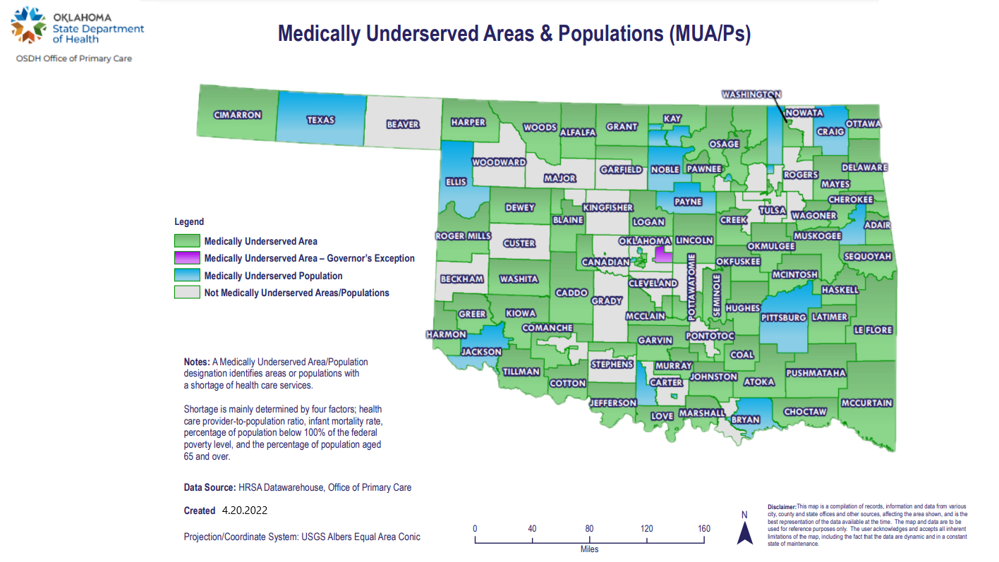
Oklahoma Medically Underserved Areas & Populations (MUA/Ps)
County-level map of Oklahoma identifying the location of Medically Underserved Areas (MUAs), Governor's Exception MUAs, and Medically Underserved Populations (MUPs).
Type: Map/Mapping System
Sponsoring organization: Oklahoma Office of Primary Care and Rural Health Development
view details
County-level map of Oklahoma identifying the location of Medically Underserved Areas (MUAs), Governor's Exception MUAs, and Medically Underserved Populations (MUPs).
Type: Map/Mapping System
Sponsoring organization: Oklahoma Office of Primary Care and Rural Health Development
view details