Rural Health
Resources by Type: Map/Mapping System
Maine Critical Access Hospitals by DHHS Districts 2014
Shows the location of Critical Access Hospitals in each DHHS District of Maine.
Date: 2014
Type: Map/Mapping System
Sponsoring organization: Maine Office of Rural Health and Primary Care
view details
Shows the location of Critical Access Hospitals in each DHHS District of Maine.
Date: 2014
Type: Map/Mapping System
Sponsoring organization: Maine Office of Rural Health and Primary Care
view details
Maine Critical Access Hospitals by County 2014
Shows the location of Critical Access Hospitals in the state of Maine.
Date: 2014
Type: Map/Mapping System
Sponsoring organization: Maine Office of Rural Health and Primary Care
view details
Shows the location of Critical Access Hospitals in the state of Maine.
Date: 2014
Type: Map/Mapping System
Sponsoring organization: Maine Office of Rural Health and Primary Care
view details
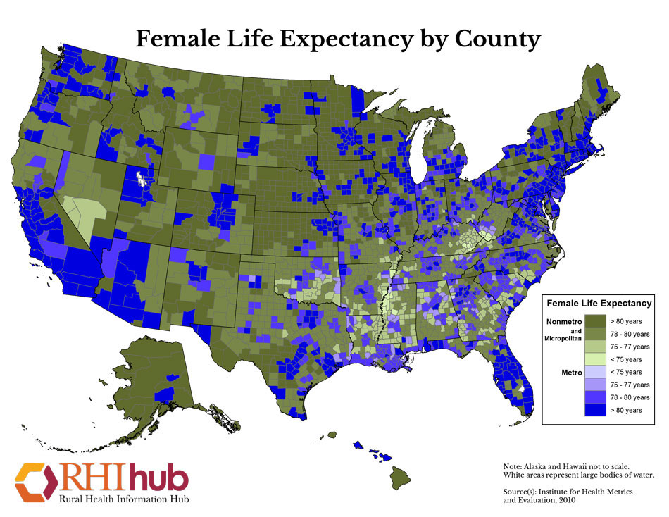
Female Life Expectancy by County
Printable map that shows the life expectancy of females nationwide by county. Data source: Institute for Health Metrics and Evaluation (IHME)
Date: 2010
Type: Map/Mapping System
Sponsoring organization: Rural Health Information Hub
view details
Printable map that shows the life expectancy of females nationwide by county. Data source: Institute for Health Metrics and Evaluation (IHME)
Date: 2010
Type: Map/Mapping System
Sponsoring organization: Rural Health Information Hub
view details
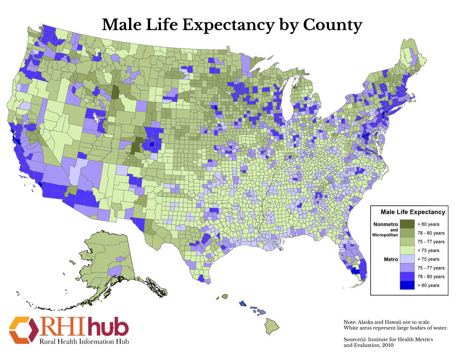
Male Life Expectancy by County
Printable map that shows the life expectancy of males nationwide by county. Data source: Institute for Health Metrics and Evaluation (IHME)
Date: 2010
Type: Map/Mapping System
Sponsoring organization: Rural Health Information Hub
view details
Printable map that shows the life expectancy of males nationwide by county. Data source: Institute for Health Metrics and Evaluation (IHME)
Date: 2010
Type: Map/Mapping System
Sponsoring organization: Rural Health Information Hub
view details
Northern Mariana Islands 2010 Census Results: Total Population by Election District
Map showing population totals by number range in Northern Mariana Island election districts.
Date: 2010
Type: Map/Mapping System
Sponsoring organization: U.S. Census Bureau
view details
Map showing population totals by number range in Northern Mariana Island election districts.
Date: 2010
Type: Map/Mapping System
Sponsoring organization: U.S. Census Bureau
view details
American Samoa 2010 Census Results: Total Population by County
Map showing county population totals by number range in American Samoa.
Date: 2010
Type: Map/Mapping System
Sponsoring organization: U.S. Census Bureau
view details
Map showing county population totals by number range in American Samoa.
Date: 2010
Type: Map/Mapping System
Sponsoring organization: U.S. Census Bureau
view details
U.S. Virgin Islands 2010 Census Results: Total Population by Census Subdistrict
Map showing population totals by number range in the U.S. Virgin Islands.
Date: 2010
Type: Map/Mapping System
Sponsoring organization: U.S. Census Bureau
view details
Map showing population totals by number range in the U.S. Virgin Islands.
Date: 2010
Type: Map/Mapping System
Sponsoring organization: U.S. Census Bureau
view details
Guam 2010 Census Results: Total Population by Municipalities
Map showing population totals by number range in Guam municipalities.
Date: 2010
Type: Map/Mapping System
Sponsoring organization: U.S. Census Bureau
view details
Map showing population totals by number range in Guam municipalities.
Date: 2010
Type: Map/Mapping System
Sponsoring organization: U.S. Census Bureau
view details
Nonmetropolitan Counties and Vet Centers
Offers a map of the United States showing nonmetropolitan counties and Veterans Affairs (VA) Centers.
Date: 2005
Type: Map/Mapping System
Sponsoring organization: North Carolina Rural Health Research Program
view details
Offers a map of the United States showing nonmetropolitan counties and Veterans Affairs (VA) Centers.
Date: 2005
Type: Map/Mapping System
Sponsoring organization: North Carolina Rural Health Research Program
view details
Nonmetropolitan Counties and VA Clinics
Offers a map of the United States showing nonmetropolitan counties and Veterans Affairs (VA) Clinics.
Date: 2005
Type: Map/Mapping System
Sponsoring organization: North Carolina Rural Health Research Program
view details
Offers a map of the United States showing nonmetropolitan counties and Veterans Affairs (VA) Clinics.
Date: 2005
Type: Map/Mapping System
Sponsoring organization: North Carolina Rural Health Research Program
view details