Rural Health
Resources by Type: Map/Mapping System
FY 2016 Small Rural Hospital Improvement Program Hospitals
Map showing all U.S. hospitals participating in the Small Rural Hospital Improvement Grant Program (SHIP) during fiscal year 2016.
Date: 09/2017
Sponsoring organization: Federal Office of Rural Health Policy
view details
Map showing all U.S. hospitals participating in the Small Rural Hospital Improvement Grant Program (SHIP) during fiscal year 2016.
Date: 09/2017
Sponsoring organization: Federal Office of Rural Health Policy
view details
Wisconsin Drive Time to Emergency Care
Shows a map of Wisconsin with drive times to Critical Access Hospitals (CAHs), non-CAHs, and freestanding emergency rooms in 10, 20, and 30-minute increments.
Date: 09/2017
Sponsoring organization: Wisconsin Office of Rural Health
view details
Shows a map of Wisconsin with drive times to Critical Access Hospitals (CAHs), non-CAHs, and freestanding emergency rooms in 10, 20, and 30-minute increments.
Date: 09/2017
Sponsoring organization: Wisconsin Office of Rural Health
view details
Wisconsin EMS Agencies Interactive Map
Provides county-level data on emergency medical service (EMS) agencies in Wisconsin. Map is searchable by level of rurality, service license level, service type, county, and Regional Trauma Advisory Committee (RTAC) region.
Date: 08/2017
Sponsoring organization: Wisconsin Office of Rural Health
view details
Rural Population Change Varies Across the United States
Map showing nonmetropolitan counties that lost population, saw population growth below 4.5%, or grew 4.5% or more between 2010 and 2016.
Date: 06/2017
Sponsoring organization: USDA Economic Research Service
view details
Map showing nonmetropolitan counties that lost population, saw population growth below 4.5%, or grew 4.5% or more between 2010 and 2016.
Date: 06/2017
Sponsoring organization: USDA Economic Research Service
view details
Uninsured Rates Decrease for Most Counties From 2014 to 2015
Two maps comparing county-level uninsured rates in 2014 and 2015.
Date: 03/2017
Sponsoring organization: U.S. Census Bureau
view details
Two maps comparing county-level uninsured rates in 2014 and 2015.
Date: 03/2017
Sponsoring organization: U.S. Census Bureau
view details
Mapping Rural Colorado: A Statistical Comparison of Colorado's Rural Regions
Outlines four distinct rural regions of Colorado: Northwest, Southwest/San Luis Valley, Eastern Plains, and Central. Provides a quick health fact for each region and includes median income levels, adult poverty rates, obesity rates, and more.
Date: 12/2016
Sponsoring organization: Colorado Health Foundation
view details
Task Force on Ensuring Access in Vulnerable Communities, Rural and Frontier: Executive Summary and Report
Reviews characteristics of South Dakota's rural and frontier communities. Identifies innovative healthcare delivery and payment models and makes state and federal policy recommendations to improve rural health. Highlights the importance of Critical Access Hospitals (CAHs). Linked map includes locations of South Dakota CAHs, Rural Health Clinics, and more.
Date: 09/2016
Sponsoring organization: South Dakota Association of Healthcare Organizations
view details
Alabama General Hospital Closures Since 1980
County-level map showing general hospitals that closed and were not replaced within two years.
Date: 03/2016
Sponsoring organization: Alabama Rural Health Association
view details
County-level map showing general hospitals that closed and were not replaced within two years.
Date: 03/2016
Sponsoring organization: Alabama Rural Health Association
view details
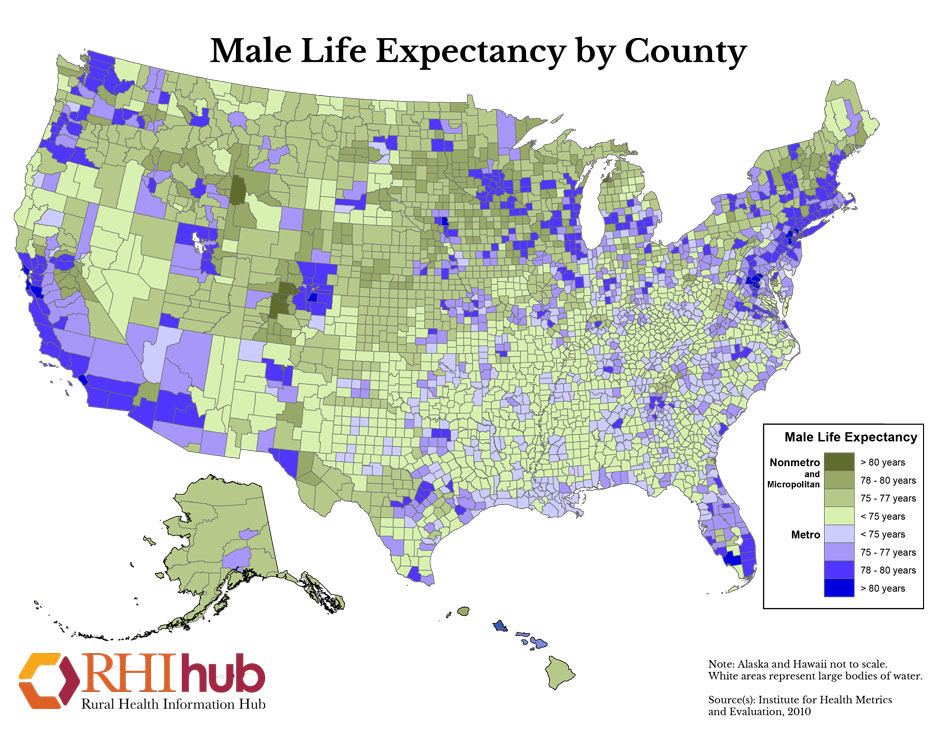
Male Life Expectancy by County
Printable map that shows the life expectancy of males nationwide by county. Data source: Institute for Health Metrics and Evaluation (IHME)
Date: 2010
Sponsoring organization: Rural Health Information Hub
view details
Printable map that shows the life expectancy of males nationwide by county. Data source: Institute for Health Metrics and Evaluation (IHME)
Date: 2010
Sponsoring organization: Rural Health Information Hub
view details
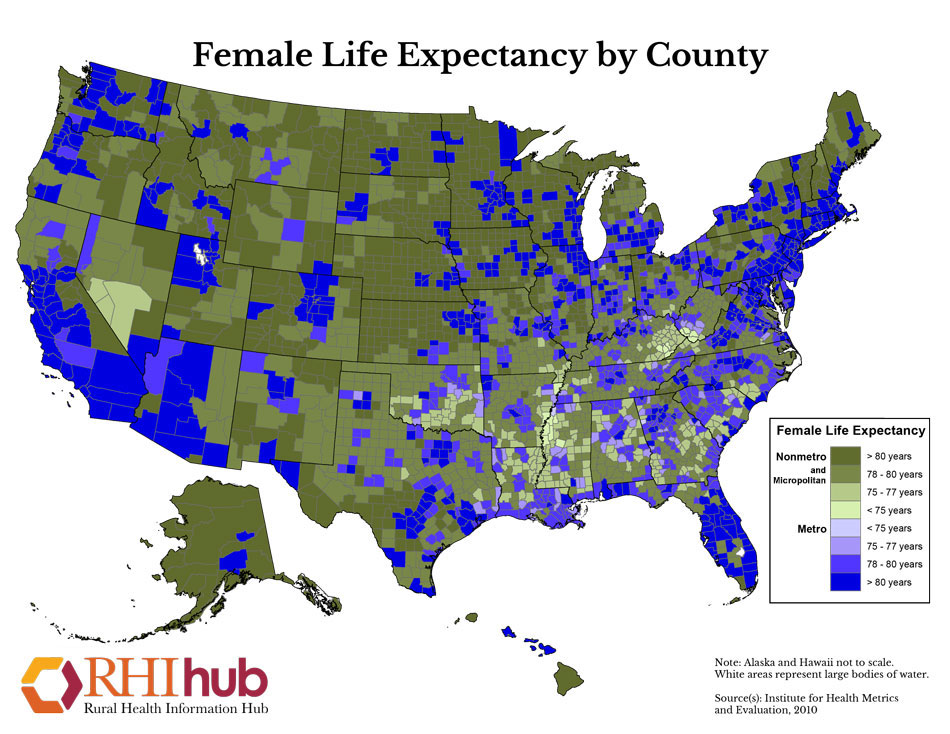
Female Life Expectancy by County
Printable map that shows the life expectancy of females nationwide by county. Data source: Institute for Health Metrics and Evaluation (IHME)
Date: 2010
Sponsoring organization: Rural Health Information Hub
view details
Printable map that shows the life expectancy of females nationwide by county. Data source: Institute for Health Metrics and Evaluation (IHME)
Date: 2010
Sponsoring organization: Rural Health Information Hub
view details