Rural Health
Resources by Type: Map/Mapping System
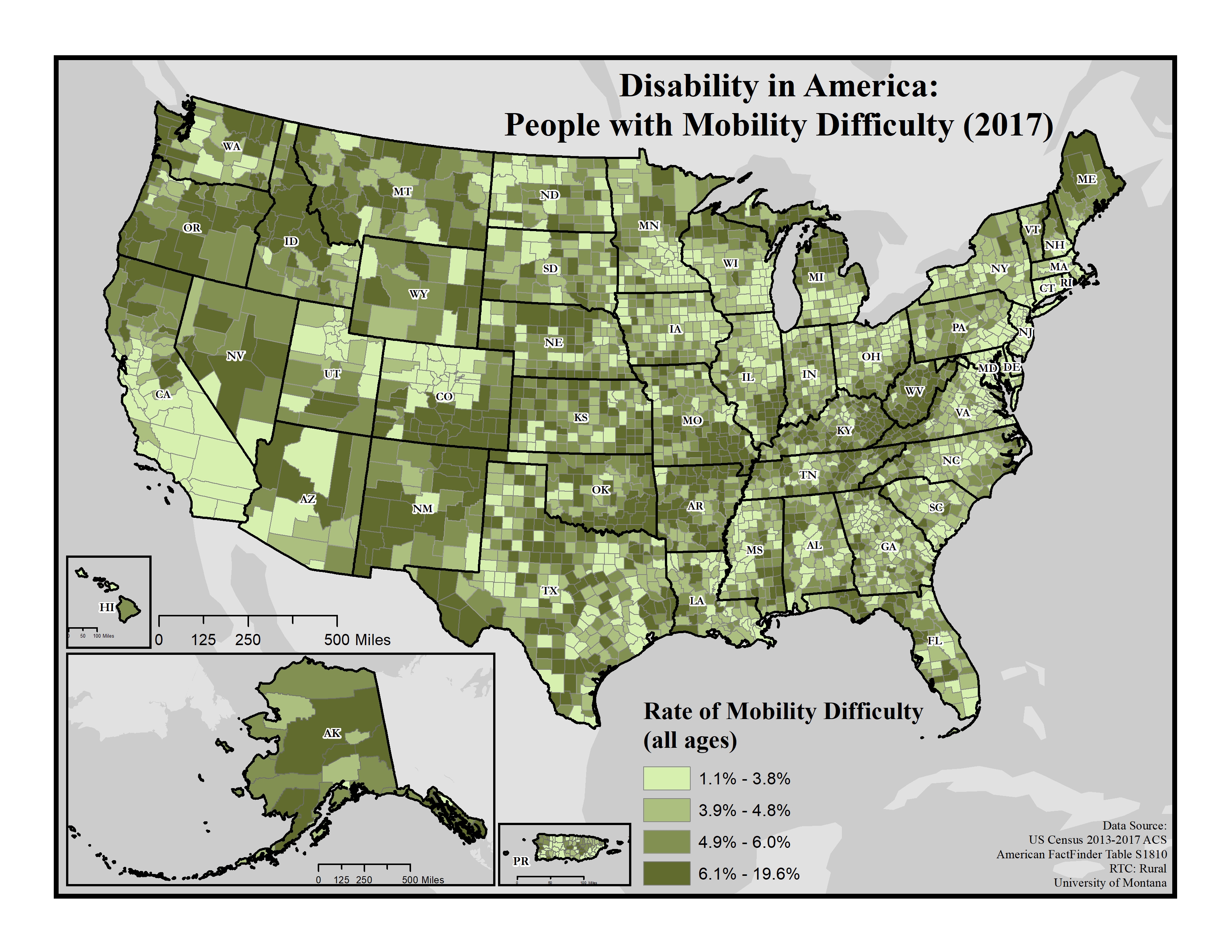
Disability in America: People with Mobility Difficulty (2017)
Displays the rate of people with mobility difficulty on the county level using data from the 2013-2017 American Community Survey (ACS).
Date: 01/2019
Sponsoring organization: Research and Training Center on Disability in Rural Communities
view details
Displays the rate of people with mobility difficulty on the county level using data from the 2013-2017 American Community Survey (ACS).
Date: 01/2019
Sponsoring organization: Research and Training Center on Disability in Rural Communities
view details
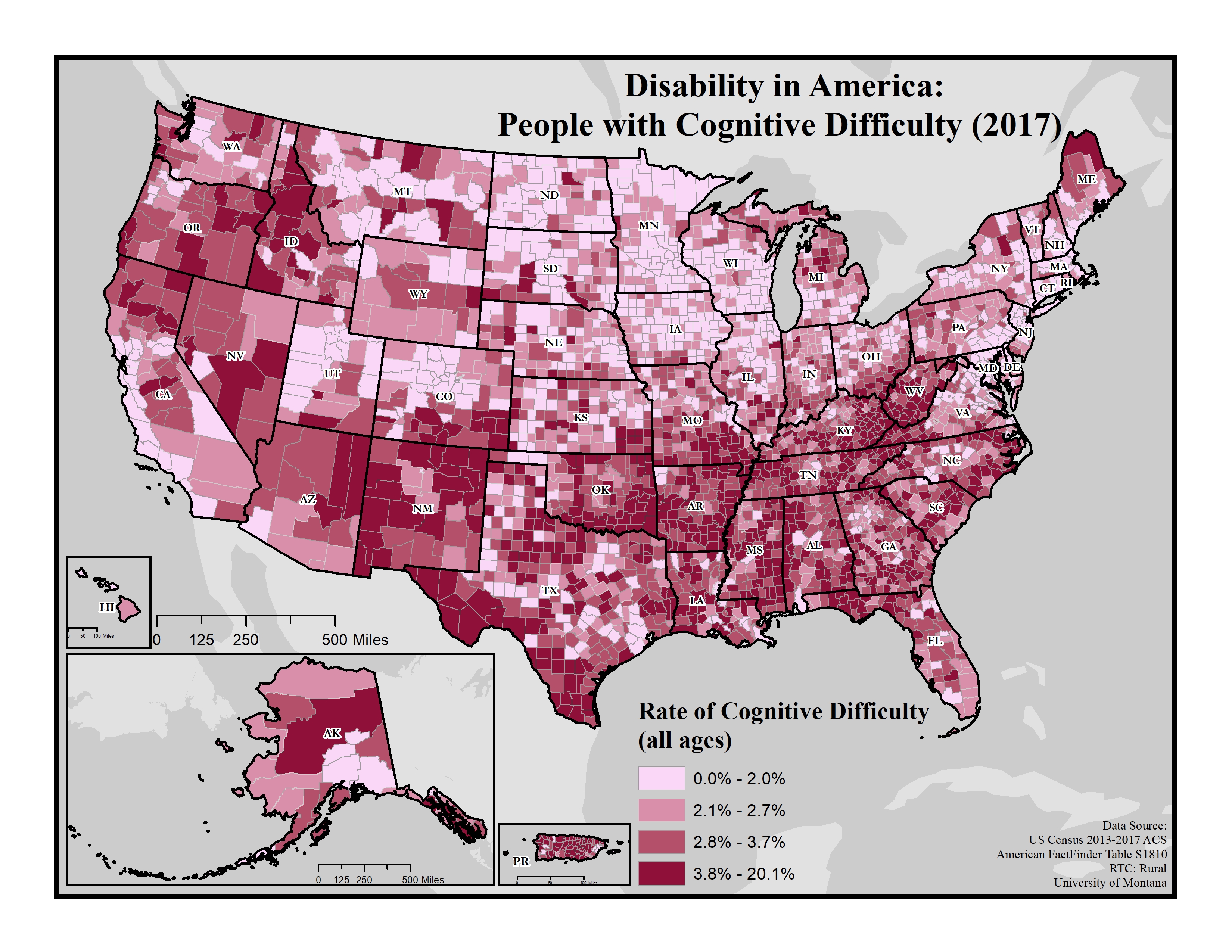
Disability in America: People with Cognitive Difficulty (2017)
Displays the rate of people with cognitive difficulty on the county level using data from the 2013-2017 American Community Survey (ACS).
Date: 01/2019
Sponsoring organization: Research and Training Center on Disability in Rural Communities
view details
Displays the rate of people with cognitive difficulty on the county level using data from the 2013-2017 American Community Survey (ACS).
Date: 01/2019
Sponsoring organization: Research and Training Center on Disability in Rural Communities
view details
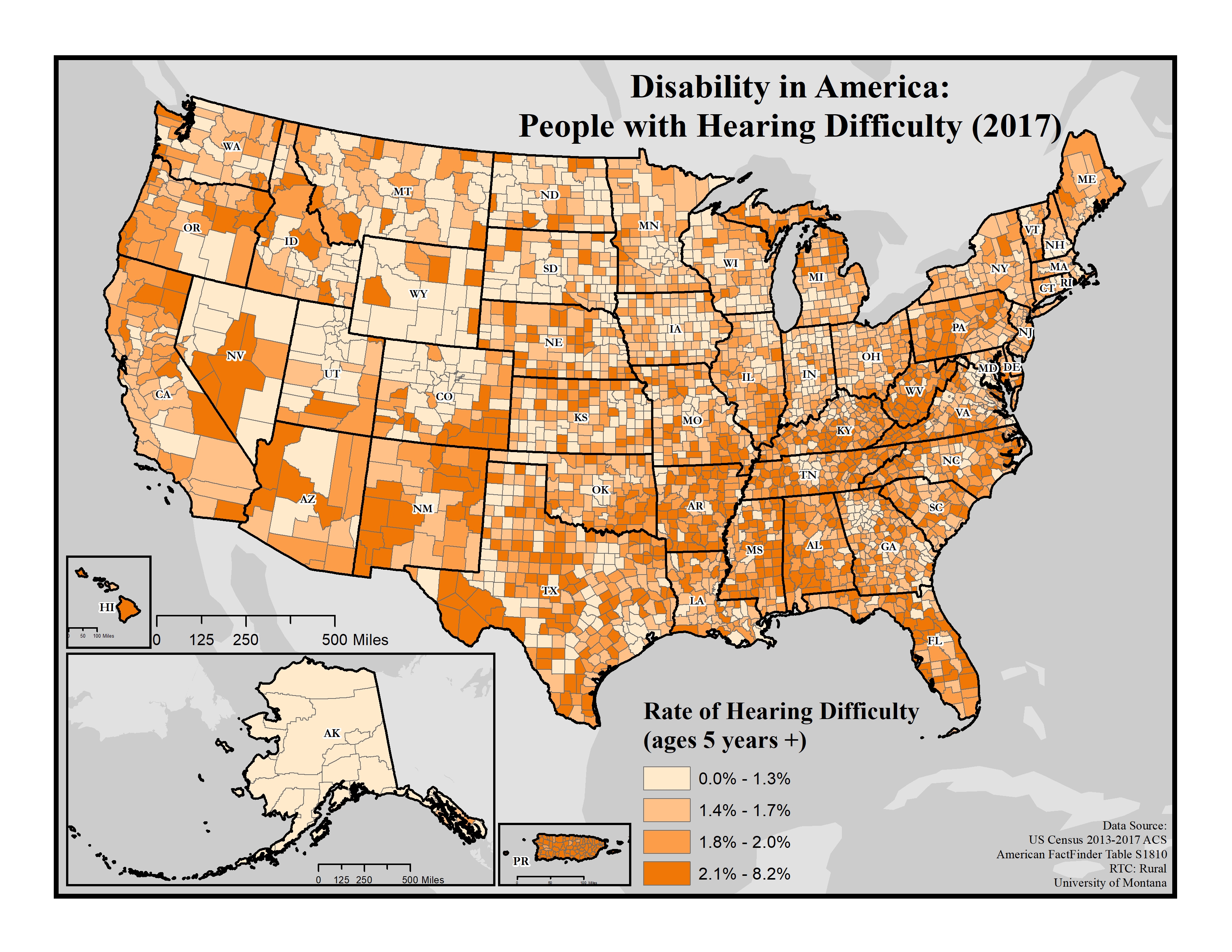
Disability in America: People with Hearing Difficulty (2017)
Displays the rate of people with hearing difficulty on the county level using data from the 2013-2017 American Community Survey (ACS).
Date: 01/2019
Sponsoring organization: Research and Training Center on Disability in Rural Communities
view details
Displays the rate of people with hearing difficulty on the county level using data from the 2013-2017 American Community Survey (ACS).
Date: 01/2019
Sponsoring organization: Research and Training Center on Disability in Rural Communities
view details
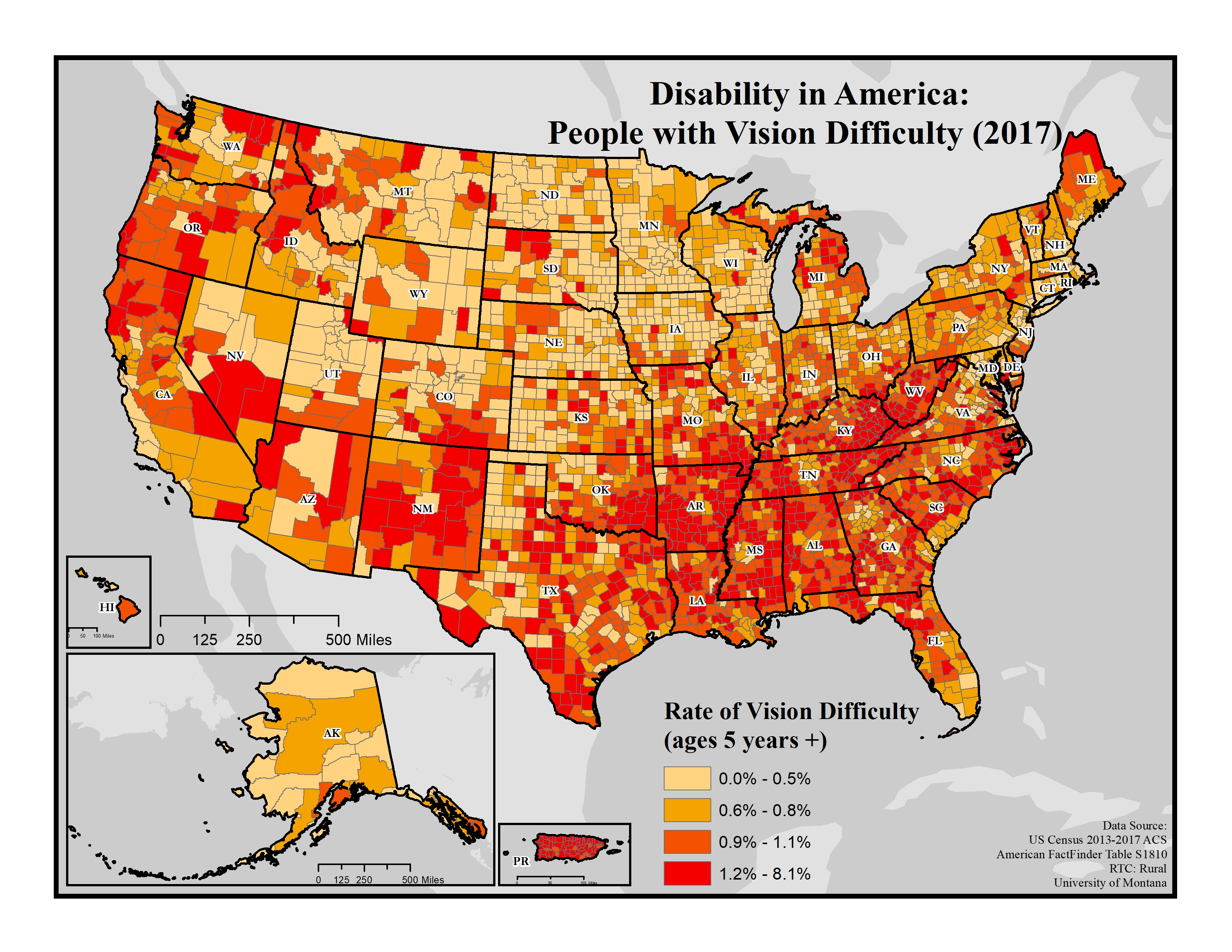
Disability in America: People with Vision Difficulty (2017)
Displays the rate of people with vision difficulty on the county level using data from the 2013-2017 American Community Survey (ACS).
Date: 01/2019
Sponsoring organization: Research and Training Center on Disability in Rural Communities
view details
Displays the rate of people with vision difficulty on the county level using data from the 2013-2017 American Community Survey (ACS).
Date: 01/2019
Sponsoring organization: Research and Training Center on Disability in Rural Communities
view details
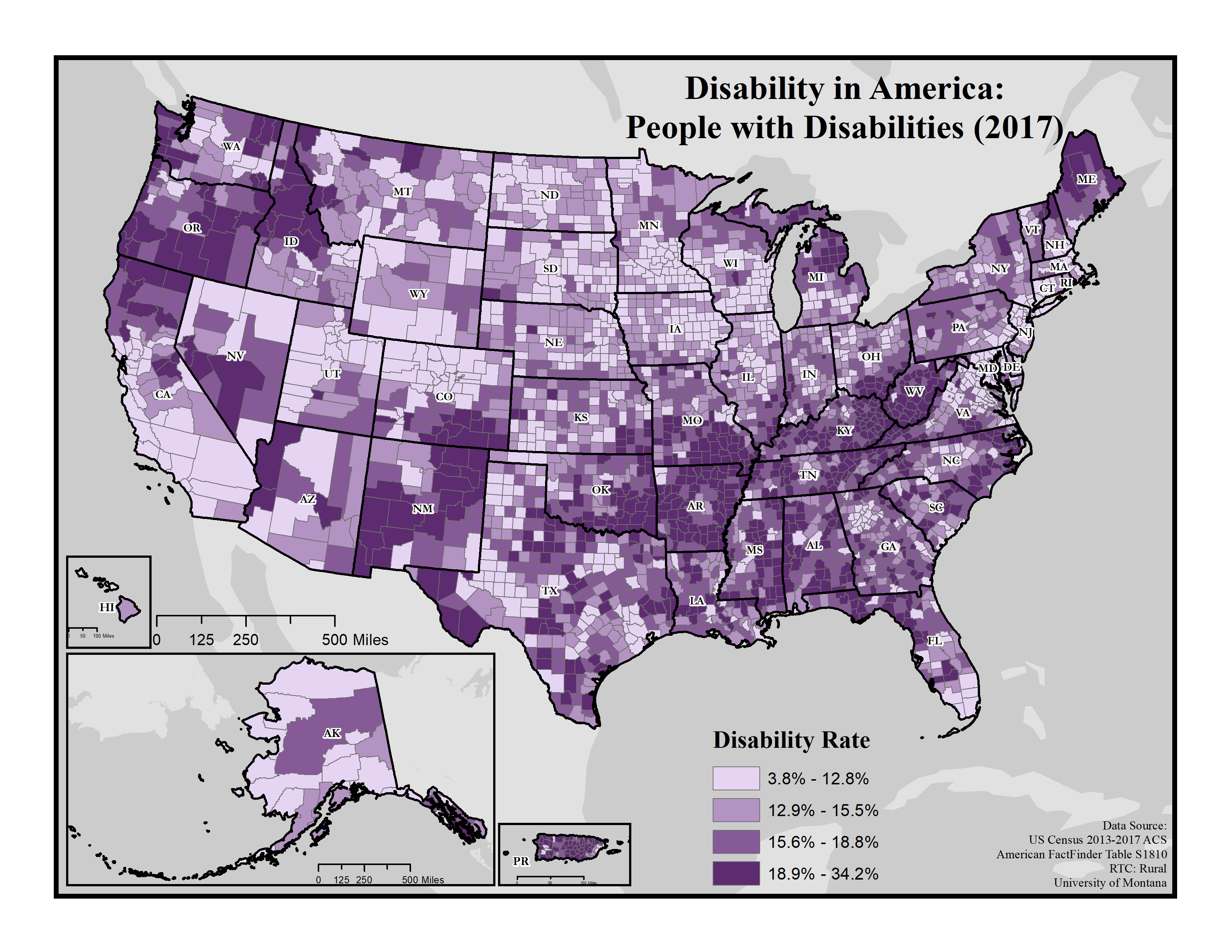
Disability in America: People with Disabilities (2017)
Displays general disability rates on the county level using data from the 2013-2017 American Community Survey (ACS).
Date: 01/2019
Sponsoring organization: Research and Training Center on Disability in Rural Communities
view details
Displays general disability rates on the county level using data from the 2013-2017 American Community Survey (ACS).
Date: 01/2019
Sponsoring organization: Research and Training Center on Disability in Rural Communities
view details
Oklahoma Drug Induced Causes of Death Due to Opioid Poisoning, 1999 to 2017
County-level map of Oklahoma, using data from the Centers for Disease Control and Prevention/National Center for Health Statistics, to show drug induced age-adjusted mortality rate due to opioid poisoning from 1999 to 2017.
Date: 01/2019
Sponsoring organization: Oklahoma State University Center for Rural Health
view details
Percentage of Households With Subscription to Any Broadband Service: 2013-2017
National map showing household broadband subscription rates by county.
Additional links: Completely Rural Counties, Mostly Rural Counties, Mostly Urban Counties
Date: 12/2018
Sponsoring organization: U.S. Census Bureau
view details
National map showing household broadband subscription rates by county.
Additional links: Completely Rural Counties, Mostly Rural Counties, Mostly Urban Counties
Date: 12/2018
Sponsoring organization: U.S. Census Bureau
view details
FQHCs, Rural Health Clinics, and Critical Access Hospitals in Oklahoma
County-level map of Oklahoma showing the locations of Critical Access Hospitals (CAHs), Federally Qualified Health Centers (FQHCs), and Rural Health Clinics (RHCs) within the state. Also shows Primary Care Health Professional Shortage Areas (HPSAs) by designation type.
Date: 12/2018
Sponsoring organization: Oklahoma State University Center for Rural Health
view details
Elder Veterans Tend to Reside in Rural Counties and Near Military Bases
Map showing counties with a concentration of working-age and elder veterans, a concentration of working-age veterans, or a concentration of elder veterans, based on 2011-2015 American Community Survey data. Also identifies locations of military installations, ranges, and training areas.
Date: 07/2018
Sponsoring organization: USDA Economic Research Service
view details
Persistent Rural Child Poverty is Also Concentrated in the South
Map showing which rural counties have high and persistent child poverty, high but not persistent child poverty, persistent but not high child poverty, and those that do not have high or persistent child poverty.
Date: 06/2018
Sponsoring organization: USDA Economic Research Service
view details
Map showing which rural counties have high and persistent child poverty, high but not persistent child poverty, persistent but not high child poverty, and those that do not have high or persistent child poverty.
Date: 06/2018
Sponsoring organization: USDA Economic Research Service
view details