Rural Health
Resources by Type: Map/Mapping System
Plains and Southeast Areas Received Largest Share of Federal Community Facilities Program's Rural Hospital Funding, 2000 to 2020
Author(s): Anil Rupasingha
Date: 04/2025
Sponsoring organization: USDA Economic Research Service
view details
Map comparing the amount of Community Facilities Program's rural hospital funding with rural hospital closures between 2000 and 2020 in the 8 Bureau of Economic Analysis geographic regions.
Author(s): Anil Rupasingha
Date: 04/2025
Sponsoring organization: USDA Economic Research Service
view details
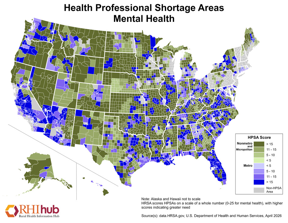
Health Professional Shortage Areas: Mental Health
Printable map that shows nonmetropolitan and micropolitan mental health HPSAs on one color scale and metropolitan mental health HPSAs on another. Data source: data.HRSA.gov
Date: 04/2025
Sponsoring organization: Rural Health Information Hub
view details
Printable map that shows nonmetropolitan and micropolitan mental health HPSAs on one color scale and metropolitan mental health HPSAs on another. Data source: data.HRSA.gov
Date: 04/2025
Sponsoring organization: Rural Health Information Hub
view details
Health Professional Shortage Areas: Dental Care
Printable map that shows nonmetropolitan and micropolitan dental care HPSAs on one color scale and metropolitan dental care HPSAs on another. Data source: data.HRSA.gov
Date: 04/2025
Sponsoring organization: Rural Health Information Hub
view details
Printable map that shows nonmetropolitan and micropolitan dental care HPSAs on one color scale and metropolitan dental care HPSAs on another. Data source: data.HRSA.gov
Date: 04/2025
Sponsoring organization: Rural Health Information Hub
view details
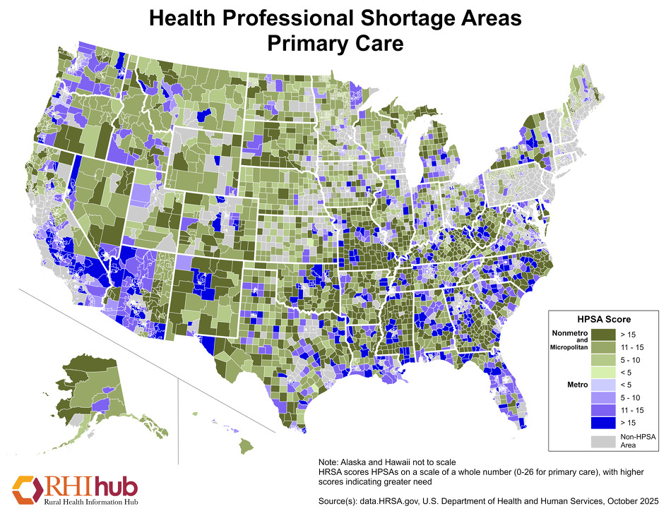
Health Professional Shortage Areas: Primary Care
Printable map that shows nonmetropolitan and micropolitan primary care HPSAs on one color scale and metropolitan primary care HPSAs on another. Data source: data.HRSA.gov
Date: 04/2025
Sponsoring organization: Rural Health Information Hub
view details
Printable map that shows nonmetropolitan and micropolitan primary care HPSAs on one color scale and metropolitan primary care HPSAs on another. Data source: data.HRSA.gov
Date: 04/2025
Sponsoring organization: Rural Health Information Hub
view details
Urban Influence Varies Widely Across the Country
Map showing the December 2024 Urban Influence Code status for counties in all 50 states.
Date: 02/2025
Sponsoring organization: USDA Economic Research Service
view details
Map showing the December 2024 Urban Influence Code status for counties in all 50 states.
Date: 02/2025
Sponsoring organization: USDA Economic Research Service
view details
North Dakota Healthcare Dashboard
Provides an overview of the current health workforce and demographic distribution throughout the state of North Dakota. Presents data in the form of graphs and maps. Allows users to select for rural, metropolitan, and micropolitan areas.
Date: 01/2025
Sponsoring organization: University of North Dakota School of Medicine & Health Sciences
view details
Medicaid Coverage in Metro and Small Town/Rural Counties, 2023
Presents county-level data for children, non-elderly adults, and seniors insured by Medicaid/CHIP. Utilizes 2023 American Community Survey (ACS) Public Use Microdata Sample (PUMS) data to provide insurance comparisons by county and by state.
Date: 01/2025
Sponsoring organization: Georgetown University Health Policy Institute
view details
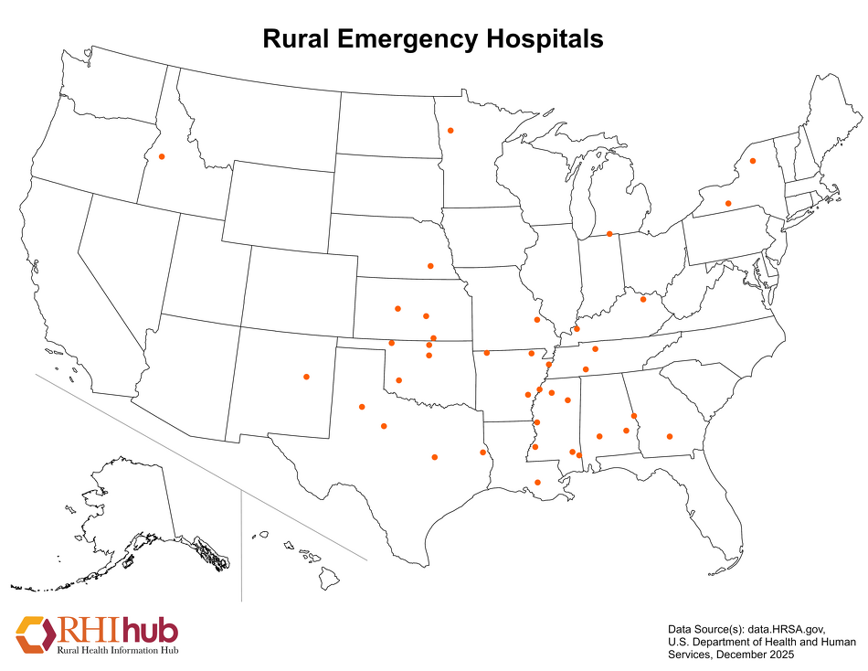
Rural Emergency Hospitals (REHs)
Printable map that shows the location of Rural Emergency Hospitals (REHs) nationwide by state. Data source: data.HRSA.gov, U.S. Department of Health and Human Services
Date: 01/2025
Sponsoring organization: Rural Health Information Hub
view details
Printable map that shows the location of Rural Emergency Hospitals (REHs) nationwide by state. Data source: data.HRSA.gov, U.S. Department of Health and Human Services
Date: 01/2025
Sponsoring organization: Rural Health Information Hub
view details
RHCs, FQHCs, Tribal Clinics and CAHs in Rural Oregon
Shows a county-level map of Oregon identifying the Rural Health Clinics (RHCs), Federally Qualified Health Centers (FQHCs), tribal clinics, and Critical Access Hospitals (CAHs). Highlights rural, urban, and frontier areas.
Date: 01/2025
Sponsoring organization: Oregon Office of Rural Health
view details
Selected Rural Healthcare Facilities in New Jersey
Shows the state's Critical Access Hospitals (CAHs), Rural Emergency Hospitals (REHs), and Rural Health Clinics (RHCs), as well as Federally Qualified Health Center (FQHC) sites and short term/PPS (Prospective Payment System) hospitals located in rural areas.
Date: 01/2025
Sponsoring organization: Rural Health Information Hub
view details